File:Occupied Palestinian Territories.jpg
Jump to navigation
Jump to search


Size of this preview: 393 × 599 pixels. Other resolutions: 157 × 240 pixels | 315 × 480 pixels | 393 × 600 pixels | 504 × 768 pixels | 672 × 1,024 pixels | 1,895 × 2,889 pixels.
Original file (1,895 × 2,889 pixels, file size: 949 KB, MIME type: image/jpeg)
Summary
| Description |
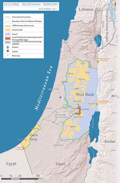
English: Map of the Occupied Palestinian Territories (West Bank and Gaza Strip), marked by the Green Line. Based on Reference Map: occupied Palestinian territory: Overview Map, as of December 2011. Published by United Nations Office for the Coordination of Humanitarian Affairs (OCHAoPt), 25 January 2012
العربية: خريطة للأراضي الفلسطينية المحتلة (الضفة الغربية وقطاع غزة) ، مميزة بالخط الأخضر. استنادًا إلى الخريطة المرجعية: "الأراضي الفلسطينية المحتلة: خريطة عامة" ، اعتبارًا من ديسمبر 2011. تم النشر بواسطة مكتب الأمم المتحدة لتنسيق الشؤون الإنسانية (OCHAoPt ) ، 25 يناير 2012 |
| Date | |
| Source | Own work, based on http://www.ochaopt.org/documents/ochaopt_atlas_opt_general_december2011.pdf on [1] |
| Author | Wickey-nl |

|
This map image could be re-created using vector graphics as an SVG file. This has several advantages; see Commons:Media for cleanup for more information. If an SVG form of this image is available, please upload it and afterwards replace this template with
{{vector version available|new image name}}.
It is recommended to name the SVG file “Occupied Palestinian Territories.svg”—then the template Vector version available (or Vva) does not need the new image name parameter. |


Licensing
I, the copyright holder of this work, hereby publish it under the following license:
This file is licensed under the Creative Commons Attribution-Share Alike 3.0 Unported license.
- You are free:
- to share – to copy, distribute and transmit the work
- to remix – to adapt the work
- Under the following conditions:
- attribution – You must give appropriate credit, provide a link to the license, and indicate if changes were made. You may do so in any reasonable manner, but not in any way that suggests the licensor endorses you or your use.
- share alike – If you remix, transform, or build upon the material, you must distribute your contributions under the same or compatible license as the original.

File history
Click on a date/time to view the file as it appeared at that time.
| Date/Time | Thumbnail | Dimensions | User | Comment | |
|---|---|---|---|---|---|
| current | 17:08, 25 March 2014 | | 1,895 × 2,889 (949 KB) | Wickey-nl | User created page with UploadWizard |
File usage
There are no pages that use this file.